This post commences a series about Virginia’s Tye River, let’s call it Tye River Tuesday. It won’t happen every Tuesday, but my aim is to write about the Tye River every third or fourth week.
Where is the Tye River? It’s in central Virginia and it’s a small river that originates in the Blue Ridge Mountains forming a tributary to the James River. The overall length of the Tye River is about 60 kilometers (37 mi.) and its drainage basin encompasses ~1075 km2 (415 mi2) in Nelson and Amherst counties.

The Tye River drainage basin in central Virginia.
One of the cascades at Crabtree Falls.What makes the Tye River watershed worth writing about on a regular basis? That’s a great question.
For one thing, the Tye River and its tributaries are beautiful streams that convey water from Blue Ridge summits to the lowlands. In transit that water cascades over numerous knickpoints, which non-geoscientists rightly call waterfalls. The most notable knickpoint is Crabtree Falls, reputedly the highest cascading waterfall(s) in the eastern United States. These knickpoints are modifying the Blue Ridge landscape and in the process creating the scenery.
When it comes to topographic relief the Tye River and its tributaries, the Buffalo and Piney Rivers, pack a bunch. The headwaters of these streams gather the runoff from the summits and slopes of mountains such as Three Ridges, The Priest, Maintop Mtn., Tar Jacket Ridge, and Pompey Mtn. then over just few kilometers drop steeply from elevations above 1,200 m (~4,000’) to the adjacent lowlands at ~200 m (~600’).

An oblique digital view (to the northwest) of the Tye River watershed (outlined in black). High elevations are red to brown, Low elevations are light gray green.One of my college roommates was so impressed with the Tye River that he named a son after the Tye (first name) River (middle name) – that’s high praise!
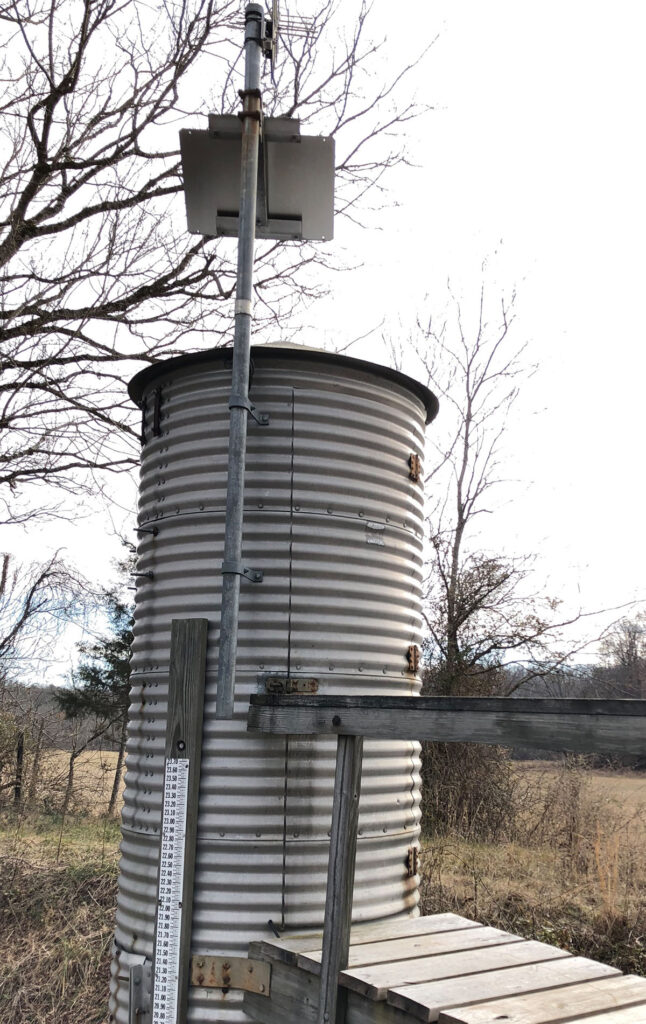
There’s a U.S. Geological Survey gauge on the Tye River and it dutifully records the ups and downs of flow in the river. The flow or discharge, measure in cubic feet per second (cfs) is highly variable. Over the past year (from August 1st, 2024), the flow has been as low as ~10 cfs and as high as ~7,300 cfs when the remnants of Hurricane Helene rolled through in late September 2024. Floods along the Tye River offer interesting lessons, and we’ll discuss those events at length in the future. There is a yearly pattern to the flow in the Tye River with the lowest median daily flows occurring from the mid-summer into the fall with the highest median daily flows in the winter and spring. What might be the reason for this seasonal pattern?

Hydrograph of Tye River flow (August 1, 2024 – July 31st, 2025) from the U.S. Geological Survey gauge.I have both personal and professional connections to the Tye River. Geographically, the watershed frames much of my research career. I’ve been fortunate to do fieldwork in lots of places – from Virginia’s green hills to British Columbia’s brilliant coastline, from the saguaro-studded deserts in southern Arizona to boggy tracts in Norway. But somehow, I keep coming back to the Tye River basin to study the rocks and structures here.

Graphic illustrating tectonic inversion and reactivation of an original normal fault.Early in my career we studied the Tye River Fault Zone in the upper reaches of the watershed. This unusual family of faults first developed as normal faults in the Ediacaran to early Cambrian (~540 Ma) these faults accommodated the deposition of sedimentary rocks in localized rift basins. Then some 200 million years later these faults were reactivated, slipping once more, but this time the faults moved the opposite direction inverting the original structures during crustal shortening.
Over the past decade we’ve studied (and continue to study) the Precambrian cover rocks in the eastern Blue Ridge including along the lower reaches of the Tye River. This sequence of rocks known as the Lynchburg Group is >8 kilometers (>5 mi.) in overall thickness and was deposited during the latest Precambrian with its cool story to tell about Snowball Earth and the break-up of a supercontinent.

Left- aerial imagery of the Tye River from Google Earth, note the large linear rock outcrop framing the southeastern side of the stream. Right- an image on the outcrop looking downstream (to the northeast), these are metamorphosed sandstones of the Lynchburg Group that are well-bedded and dipping steeply to the southeast (right).The Tye River basin is home to Virginia’s state rock – nelsonite. In 2022-3 my research team investigated this unusually weird rock. Composed primarily of apatite and ilmenite, it’s an igneous rock with almost no silica it in! WTF? Hannah Tebben’s thesis research revealed that the nelsonite dikes are ~950 million years old, more than 50 million years younger than previously thought.

Nelsonite, Virginia's state rock.And just a week ago with my colleague Dr. Joanmarie Del Vecchio and our undergraduate research student Nick Lewis, we started a new study focused on knickpoints on the Tye and Piney Rivers as we look to discern how this dramatic topography came to be.

Dr. Joanmarie Del Vecchio (left) and W&M undergraduate Nick Lewis (right) pondering a knickpoint along the Piney River.There’s so much geoscience to discuss with the Tye River; from its hydrology to landscape evolution, from modern weathering in central Virginia to billion-year-old rocks. This is going to take a lot of Tuesdays.

View of the Tye River's confluence with the James River (muddy). The crest of the Blue Ridge Mountains at elevation above 1,200 m (4,000'), at the head of the Tye River watershed are visible in the background. The view is to the northwest.
1 thought on “TYE RIVER TUESDAY”