This post is an introduction to my new blog- Chuck’s Wonder World. I’m a geology professor at William & Mary; my teaching and field research take me to places from southeastern Virginia to Oman. There’s plenty of geological wonder in this world and my purpose here is to share that wonder in an approachable and scientifically interesting way.
I’ve spent nearly 30 years at William & Mary where teaching and conducting research are exciting. From 2008 to 2024, I contributed to the William & Mary blogs, and it was good fun while it lasted. At some point, W&M’s market research consultants concluded that both prospective and current college students don’t read and as such blogs were dinosaurs, relics of a bye-gone era.
Thanks to Mark and Jesse Windley at University Communications my old posts are archived and still have a home; perhaps there is value in that body of work. That blog was also meant to communicate to a broader audience than just those in academia; since the old blog was retired more than a few folks have asked me to craft something new.
Here, I begin a new endeavor – it’s a blog with lots of words that should, of course, be read, but it’s stuffed with more graphics, more pictures, and more videos.
As Sturgill Simpson sings on his album Metamodern Sounds in Country Music (a metamodern classic, in my opinion).
“Well, a picture’s worth a thousand words, but a word ain’t worth a dime”
So, we shall see if there is an audience for this type of content.
Overhead & Underfoot. I’ve tried to encapsulate my interests in those two compound words – counterposed by a devilishly clever ampersand.
OVERHEAD
I enjoy looking up and out at the sky as there is much to see overhead. We spend our lives at the base of the atmosphere, a blanket of gases and other compounds which shield us from the cold hardness of space. Overhead, the sky changes in real time, from the richness of a colorful sunset to the inky darkness on a moonless night; from a blue bird clear morning sky to the menacing afternoon crackles emanating from thunderclouds. There is drama galore overhead.
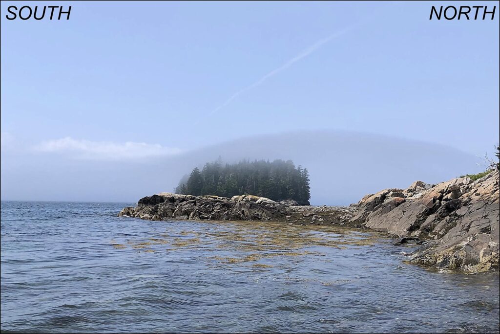
A small cloud cap developed over and downwind of Dram Island near Sorrento, Maine. The wind is blowing from the south, and the moist marine air is lifted as it passes over the island. That lifting and the associated adiabatic cooling is sufficient to cause condensation and development of a gauzy cloud.For years, I’ve filmed ‘weather video snippets’- these 45 to 75 second videos capture the local weather at a moment in time. I employ these videos in my Weather, Climate, & Change course as a means to engage students by asking them to describe what they see happening in the atmosphere. One popular question is from which direction is the wind blowing? Check out this video and figure it out for yourself.
That video captures the contained ruckus of a windy afternoon on a beach near Ras al Jinz in eastern Oman. Interestingly, this time of year the wind kicks up nearly every afternoon and blows on shore from the Arabian Sea – this is an onshore breeze which develops as a consequence of differential heating of the land relative to the sea. As the day wears on, the sun warms the land, which heats the air above driving expansion causing the air to rise overhead. The thermal inertia of water keeps the sea from heating up as quickly as the land, and effectively the cooler sea air is drawn towards the land to replace the rising air that’s onshore.
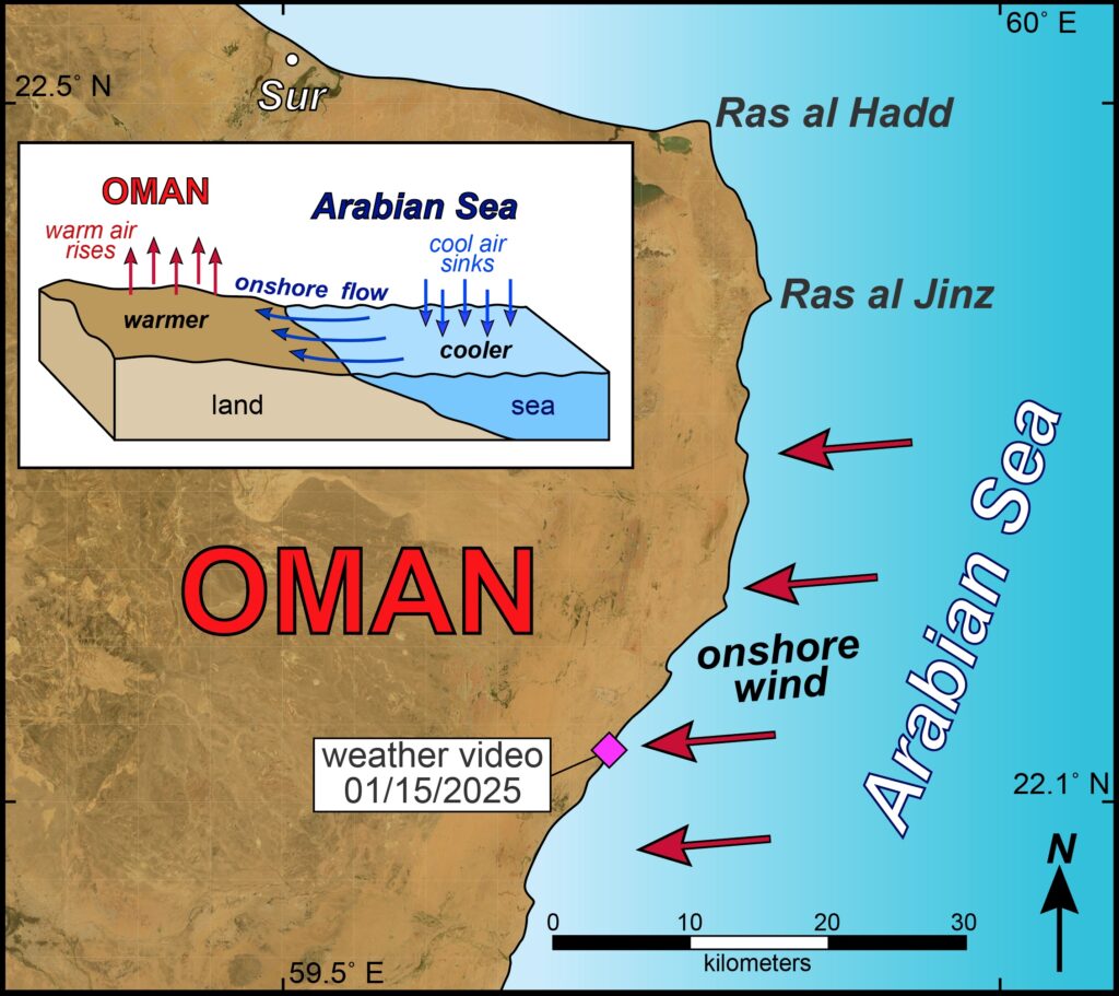
Graphic illustrating an onshore wind in eastern Oman.UNDERFOOT
What’s underfoot? I’ve spent a career working to understand what’s underfoot, that is – what’s the structure or the architecture of the Earth’s crust. The topography of our planet is varied: from pancake flat basins to noble mountain ranges. How does this topography come to be and how does it change over time? Well, it’s all connected to the Earth structure that’s underfoot.
For me, one of America’s most dramatic landscape scenes is Colorado’s Front Range rising from the Great Plains. This scene also inspired Katharine Lee Bates who penned
“…For purple mountain majesties, Above the enameled plain!”
in her 1893 poem Pikes Peak which ultimately became the foundational lyrics for the song America the Beautiful.
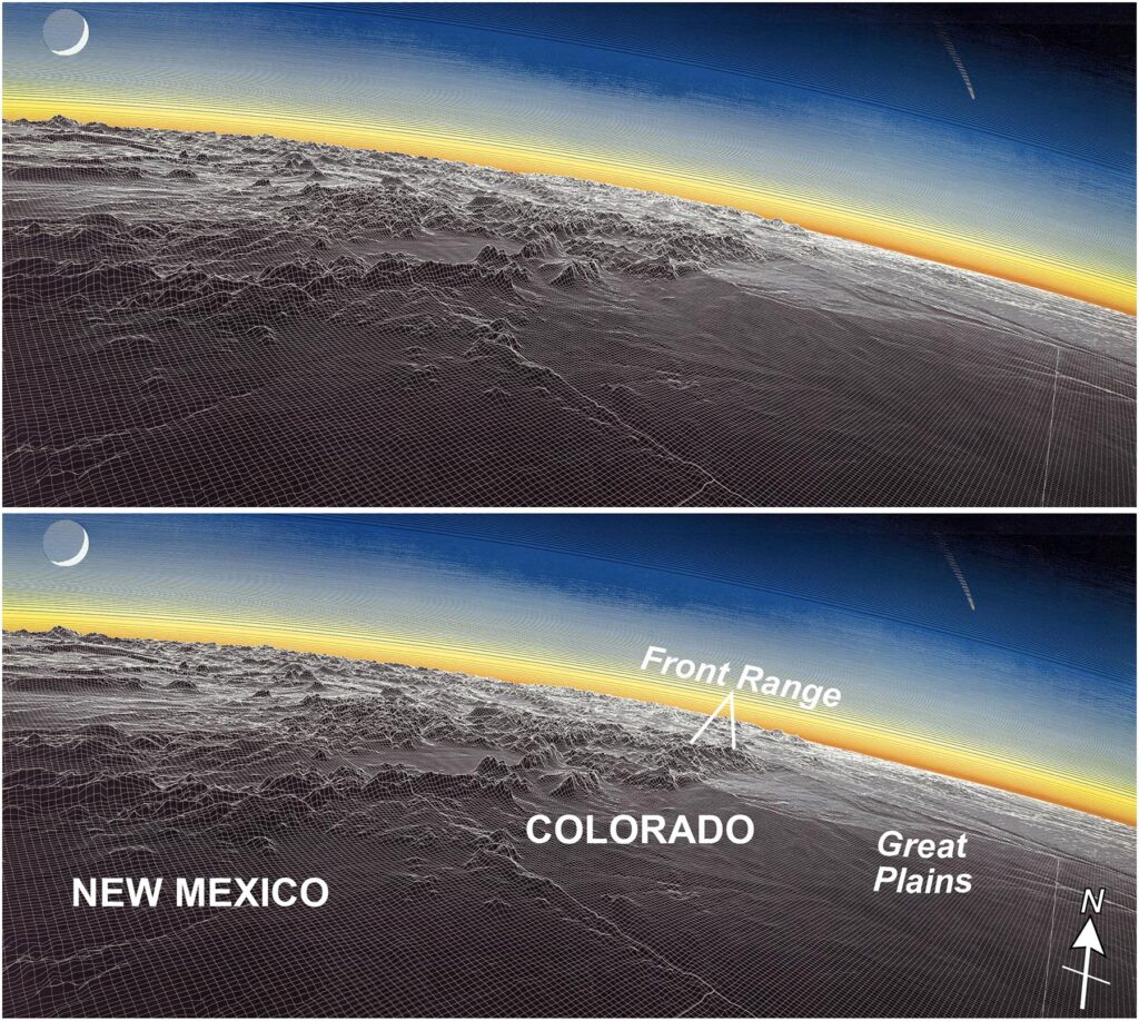
A Raven Maps image of the Rockies, High Plains, and Intermountain West which adorns my office wall, its got an old school mesh frame that illustrates the topography. Note that the topographic relief is greatly exaggerated. Also notice that the crescent moon is illuminated by a sun that appears to have set far to the north!Eighty-nine years later (1982), as a disheveled teen-aged boy scout, I had the opportunity to cross a swath of the continent on a bus en route to the Philmont scout ranch in northern New Mexico. On a July afternoon, as our bus rolled across the Great Plains headed for an overnight stop in Colorado Springs, I fought for a window seat because I’d never seen the Rockies with its bare summits above timberline. In the afternoon haze, on the southwest run from Limon to Colorado Springs, the Rockies slowly emerged above the horizon. I was a happy camper.
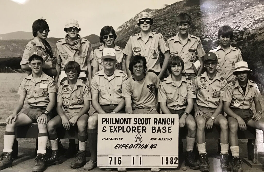
My first foray to the Rockies in July 1982. I’m squinting at the camera in the far right on the back row.That was over 40 years ago, but I still get excited whenever I see that view. These days I fly a lot, and Denver is one airport that I commonly frequent, and from here the view of the Front Range is awesome. As the Immediate Past President of the Geological Society of America I’ve spent plenty of time at our headquarters in Boulder, Colorado. Its location was well chosen as it is right where the Plains end, and the Rockies begin.
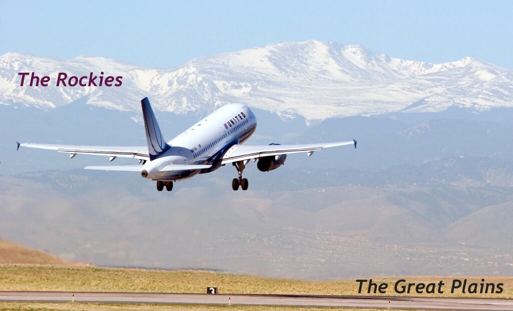
A westbound United Airlines flight departing Denver International Airport. The airport is in the Great Plains and the Front Range of the Rockies is evident in the distance.But why here? The crustal structure underfoot controls this scenery. The Great Plains are underlain by sedimentary rocks, most of which are flat-lying to gently inclined, underlie the Great Plains – for a structural geologist it’s rather bland and boring. But in mid-Colorado the crustal structure changes for the better, as over a short distance these strata are dramatically tilted and upturned. Boulder’s famous flatirons are not only classic examples of erosion-sculpted tilted layers, but scenic landforms attesting to the geologic drama that created the Rockies.
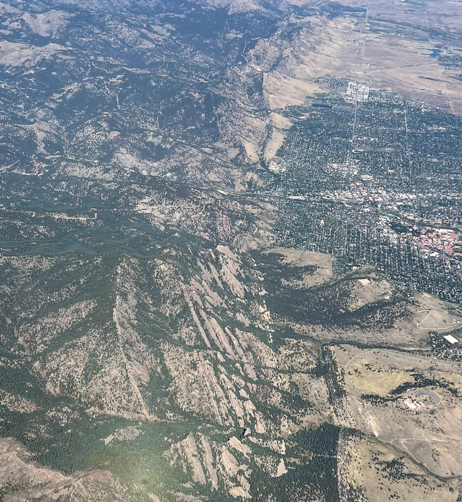
Aerial view of Boulder, Colorado. Note the flatirons to the west (left) of downtown.A few miles further west, old (>1 billion years old) igneous and metamorphic basement rocks are exposed in the Front Range. These basement rocks also underlie the Great Plains, but they are not exposed here, rather they remain buried beneath thousands of meters of sedimentary cover rocks. Pikes Peak, in all its purple mountain majesty, is underlain by a distinctive red-hued granite that crystallized ~1.08 billion years ago. Heading due east from Pikes Peak you have to traverse more than 2,300 kilometers to find similarly aged basement rocks exposed at the Earth’s surface in Virginia’s Blue Ridge Mountains.
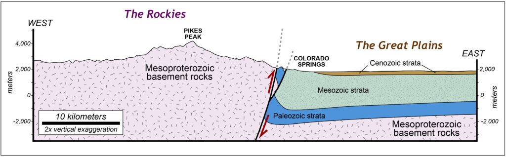
Simplified geologic cross section across the Front Range of the Rockies near Colorado Springs, Colorado.What caused all this geological upheaval? It’s the Laramide orogeny, a much-debated episode of mountain building that occurred from the latest Cretaceous into the Paleogene (~70 to 50 million years ago). Most orogenies affect the edge of continents as tectonic plates bump and grind, but the Laramide orogeny is intriguing as it reached deep into North America’s interior.
There you have it – Overhead & Underfoot. I hope you’ll return later this week for another post about our world of wonder.
“Above the enameled plain” doesn’t quite have the same ring to it, but I found that tidbit interesting. This is a very neat overview of the Rockies, and it is very fitting that the Geological Society of America calls Denver its home.